MarSSIES
MarSSIES Maritime Safety & Security Information Exchange System
• visualization and exchange information
• basic tool for maritime traffic monitoring, security and environment protection
MarSSIES concept
• Goals:
o The system creation was started in 2003
o Exchange of information between
Polish Maritime Administration
and EMSA SafeSeaNet – it was the beginning …
o Exchange of information between
Polish Maritime Administration
and allied services (Coastguard, Navy, SAR, Customs and other emergency services)
o Exchanging information gathered by different sources
presenting it in an integrated way,
• Objectives
to provide Authorities and Allied Services with operational information:
o To facilitate usage of existing systems
o To enable smooth incorporation of new systems, sensors, etc. [open architecture]
o To provide data for users as per their needs and tasks performed in a secure way
o To provide users with reliable simultaneous messaging and alerting feature
o To provide intuitional GUI and „light-weight” application for remote and mobile users
o To be fully compilant with national legislation, EU Directives, international and regional conventions
o To be fully operational with EU SafeSeaNet , EMSA CleanSeaNet
• Concept
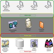
Idea of implementation of 3 layer system:
o User layer
o Access layer
o Source layer
• Multiple data integration
data sources:
o Vessel Traffic Monitoring infrastructure
AIS, VTS, EMSA SafeSeaNet, CleanSeaNet
o Navigational Data
ENC (S-57), Navigational Warnings, Notices to Mariners, Operators Graphical Layers
o Hydrometeo
wind speed and direction, sea state, forecasts, met observations
o Safe Messaging System
alerting, exchange of data, file transfer, voice communicator (VoIP, VHFoIP), chat, fax, mail
o Internal / External databases
EMSA SafeSeaNet, Lloyds, IMDG, Port Systems, PHICS
o Other sources
Pilots, PSC, Oil Terminals, Yacht Marinas, ISPS data for Regional Contact Point, Landbased Regional Crisis Centers
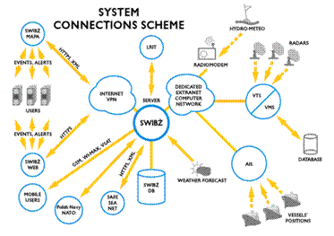
• System interconnections
• One–stop–shop system
o Solution characteristic:
data integration
presentation on MarSSIES-WEB and MarSSIES-CHART
Traffic Monitoring and Information Exchange
Events and Alerts (manual or automatic, triggering and processing)
o Simultaneous teamwork:
Reporting module
Archives (record and replay)
Full access rights control
Security (login and password, SSL protocol, VPN, etc.)
o One-stop-shop for local, remote and mobile user.
Scope of actual users
VTS (VTMS) – identification and tracking
MAS – Maritime Assistance Services
Marine Environmental Protection Inspectorate
Harbour Masters
Small ports / Marinas
Coastguard
SAR – Search and Rescue
Customs Office
Fishing Control Inspectorates
Landbase Regional Crisis Centres
Landbase Central Crisis Centres
Polish Navy
Examples of system functions
Features:
• S-57 ENC cells and Navigational Warnings uploaded ON-LINE by Hydrographic Office of the Polish Navy
• S-52 data presentation
• Information on new navigational dangers, temporary changes
• Navigational warnings (graphic and text presentation)
• Basic geographical data – e.g. ISPS Port Facility areas and PFSO contact details
• Unlimited number of additional layers – wrecks, description database, planned routes, polution areas, exercise areas, etc.
• Passage lines / areas which can trigger alerts upon any / individual vessel passing
• All data presented on the chart are stored in the system database
• Comprehensive traffic overview
• Presentation of: AIS, VTS, radar,
• Monitoring of aids to navigation (AtoN)
• Waving forecasts
• Weather forecasts
• Historical data retrieval and display
• Selective vessels monitoring and alerting (e.g. hazarous vessels, banned, SHT, waste, small crafts …)
• Suport of the allied services (Customs, Immigration)
• Facilitation of the port operations (pilots, tugs)
Commented systems screenshots:
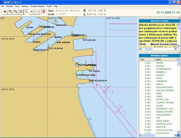
MarSSIES-CHART: View of the Port of Gdynia
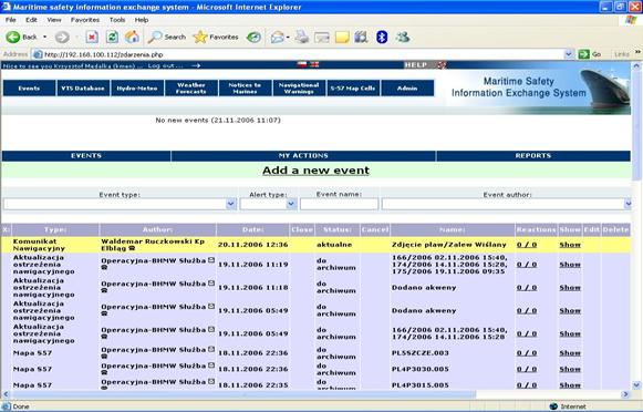
MarSSIES-WEB: Main event screen
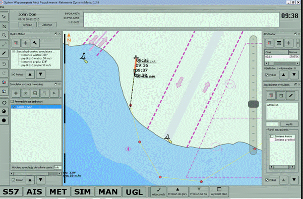
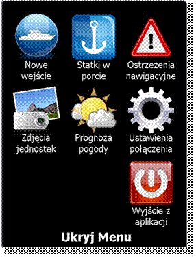
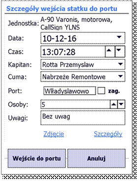
MarSSIES-TUCH: new touchable GUI