AIS+ Weather Information
1. Brief Description (PP Press or 1-2 page info paper)
Display of Meteorological and hydrographic data on a separate PC screen onboard a ship
See: Markus Porthin, Robin Berglund and Lauri Seitsonen: AIS+ – facilitating on board use of AIS Application-Specific Messages. Proceedings of E-Navigation Underway Conference, Copenhagen, Denmark and Olso, Norway, 31 January – 2 February, 2011, pp. 41 – 48. (Included in e-NAV9-INF8.)
– Display type ( such as RADAR, ECDIS, ECS or Head up display)
2. Functional Capabilities (types of data à information content)
AIS+ is an application for receiving and sending AIS ASMs using a user-friendly user interface. The software can be run on a normal PC connected to the AIS transmitter through the Pilot plug. AIS+ reads AIS messages from the serial or USB port of the computer, decodes them and visualizes the information content. It also codes user inputs into AIS ASM messages and sends them to the AIS transmitter for transmission. The ASMs currently implemented in AIS+ are: Meteorological and hydrological data (FI = 11, FI = 31), Area notice (FI = 22 and 23) (receiving), Number of persons on board (FI = 16), Dangerous cargo indication (FI = 25) and Area notice (sending) [2], [3], all defined under the international designated area code (DAC = 1).
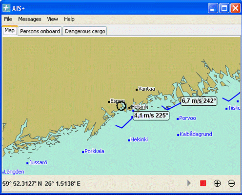
The main view of the AIS+ program is shown in the figure below. The map view shows the vessel’s current own position with a black circle. The location information is retrieved from the vessels own position report AIS messages and the map by default follows the vessel. The map also shows major place-names and lighthouses depending on the zoom level of the map. The wind barbs with an attached wind speed and direction display show the current wind gust at available weather observation stations.
By clicking the wind information on the main display one can see the observation history at the weather station as shown in the figure below. The history data is logged by AIS+ from the real time observations received as ASMs. Currently the Finnish weather stations transmit average wind, wind gust, air pressure and relative humidity observations and the user can select which data is shown in the graph. The dialog shows the observation graphs for the last 24 hours. The latest received data for the other weather parameters defined in the met/hydro message (FI = 11, FI = 31) can also be viewed, but a graphical display of them is currently not implemented.
3. Intended Purpose (including benefits)
Display of meteorological and hydrographic information
4. Portrayal examples (means or methods of portrayal)
a) good examples
– Graphic display in a chart gives the mariner real time wind speed and direction directly linked to a geographical position.
– Usage of standard wind barbs
– Information both as symbol (wind barbs), alphanumeric and time series graph
– Additional information including 24h history graph is received by clicking the symbol. History fluctuation easily spotted at a glance.
b) lessons-learned
– Information displayed in multiple ways pleases users with different preferences
– Both advantages and disadvantages in having the weather information on a separate screen. Some real time information could also be integrated in ECDIS on demand.
c) some concerns
Risk for cluttering if displayed on ECDIS